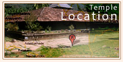
Location and access to temple
The Temple is located at an altitude of about 900 mts in north Wayanad in a valley surrounded by mountains and beautiful forests. The temple faces east where sun rises over the Udayagiri range. At the north is the formidable Brahmagiri Range which appears so close to the temple. You can see the trees and the undulating grass slopes of Brahmagiri from the temple compound. At the west and south are Karimala and Narinirangimala respectively.
A short walk from Thirunelli temple leads one to the clear mountain spring known as Papanasini. Pakshipathalam, an interesting trekking centre, is about 10 kms away from here.
How to reach Thirunelli
The journey to Thirunelli itself unravels the ravishing beauty of the high ranges of Kerala.
If it is from Calicut (Kozhikode), one has to come through Thamarasserry, climb the hair pins of the ghat road and pass the towns Kalpetta and Mananthavady.
If it is from Bangalore, arrive Mysore and then proceed to Thirunelli through Hunsur and Nagarhole.
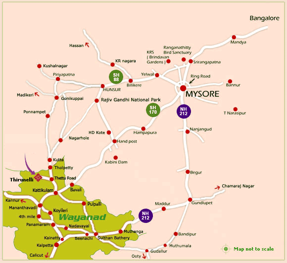
Thirunelli Temple is located at Thirunelli, 137 kms from Calicut, 121kms from Mysore and 250 kms from Bangalore. You can reach the temple only by road. When coming from outside Wayanad, the most convenient railhead is Calicut. From there proceed to Mananthavady and then to Thirunelli by taxi or bus. The total distance from Calicut is 137 kms when cominig through Koyileri - Mananthavady road. It becomes 141 kms, when coming through 4th mile - Mananthavady road. The nearest airport is Karipur near Calicut, 160 kms away.
From Calicut
The journey to Thirunelli unravels the ravishing beauty of the high ranges of Kerala. From Calicut, after an hour travel along National Highway 212, the climbs with hair- pin curves start, which amaze any traveller. There are nine hair pin bends. The sight from the ninth hair pin bend is marvellous. You can see the valleys of Calicut district as in a mirror. From there, passing Vythiri and Chundale towns, you reach Kalpetta, which is the head quarters of Waynad district. After two kms from Kalpetta town, the road deviates left to Mananthavady, a medium town.From Kannur
The journey is through Koothuparamba, Nedumpoyil, Periya, Thalappuzha and Mananthavady. The distance is 121 kms to the temple. There is a shorter route through Kelakam, Kottiyur, Boy's Town and Manathavady.From Mananthavady
, drive another 10 kms along the Mysore road to reach a small town called Kattikulam. From Kattikulam, the journey is through thick forest. Jumbo gangs trampling the bamboo bushes are a common sight on the way to Thirunelli. Occasionally other wild animals like bison, spotted-deer, peacock and so on also emerge from the wilderness. To reach Thirunelli you have to take a left turn at Thettu Road junction which is 8 kms away from Kattikulam. From Thettu Road junction drive another 13 kms to reach Thirunelli Temple.Please note: (From Thetturoad junction, when you drive almost 7 kms. there is a right tar road towards Appappara. Don’t go along that road. From this junction when you drive 3 kms straight, you may see the signboard of Thirunelli police station on the left side. Don't go along this left road. From police station junction, you further drive 3 more kms tp reach Thirunelli Temple).
From Bangalore
When coming from Bangalore side, first arrive at the ring road in Mysore. Then turn towards KRS Road and reach Vrindavan Junction. From there take the road leading towards Hunsur town. From Vrindavan junction the distance to Hunsur is 28 kms. At Hunsur, immediately after the KSRTC bus stand, take a left turn towards H.D Kotta road. Since the Hunsur road is very broad, the deviation to H.D Kotta may not arrest your attention. (Please note that the road to right is towards Kushalnagar). Hunsur-H.D Kotta distance is 32 kms. But you travel only 8 kms along this road. At the 8th Km, take a right turn towards Rajiv Gandhi National Park (old Nagarhole National Park). At the forest checkpost you have to sign to proceed further. From the checkpost drive one more hour to reach Kutta (near the Karnataka border). Please maintain a speed limit of 30-40 kms per hour along this road, since animals like deer may leap across. The drive through the forest is a very pleasant experience. This road ends near Kutta police station. There you enter the Mananthavady road. At this junction, take left, and drive another 2 more kms to reach the Kerala-Karnataka border called Tholpetty. (Note that the distance from Hunsur to Kutta is 56 kms. Kutta town is on the right side, 600 metres from Kutta police station junction).From the Kerala - Karnataka border, you may drive another 7.4 kms along the Mananthavady road to reach a desolate junction called Thetturoad Junction (landmark - a lone tea stall, a forest quarters and sign boards to Thirunelli temple). At this junction take a ‘U’ turn towards right and drive 13 kms straight, to reach Thirunelli Temple.
Please note: (From Thetturoad junction, when you drive almost 7 kms. there is a right tar road towards Appappara. Don’t go along that road. From this junction when you drive 3 kms straight, you may see the signboard of Thirunelli police station on the left side. Don't go along this left road. From police station junction, you further drive 3 more kms tp reach Thirunelli Temple).
From Mysore
When coming from Mysore one can reach Thirunelli through an alternate route along Mysore- Mananthavady road. For that drive almost 105 kms upto Kattikulam along the Mysore - Manathavady road which passes through Handpost, Kabani and Bavali. In this route after Handpost (near H.D. Kotta) the main road gets diverted through the village area for about 12 kms. That portion of the road is comparatively bad. In the forest road from Kabani to Bavali, there are intermittent humps making the driving uneasy. The small town Bavali is in the Karnataka - Kerala border. From Bavali it is 7 kms to Kattikulam. When you reach Kattikulam junction you may take a right turn and drive 8 kms to Thetturoad, a junction in the middle of the forest. From there drive another 13 kms to reach the temple.Please note: (From Thetturoad junction, when you drive almost 7 kms. there is a right tar road towards Appappara. Don’t go along that road. From this junction when you drive 3 kms straight, you may see the signboard of Thirunelli police station on the left side. Don't go along this left road. From police station junction, you further drive 3 more kms tp reach Thirunelli Temple).
Distance from Thirunelli Temple
Calicut Railway station -137 kms
Mysore Railway station -121 kms
Calicut (Karippur) airport - 161 kms
Bangalore airport - 280 kms
Distance from main cities
| City | Root | Distance |
|---|---|---|
| Bangalore | Mysore- Hunsur –Nagarhole- Kutta - Temple | 250 kms |
| Bangalore | Mysore - Handpost - Bavali - Kattikulam – Temple | 255 kms |
| Mysore | Hunsur – Nagarhole-Kutta - Temple | 120 kms |
| Mysore | Handpost - Bavali - Kattikulam - Temple | 125 kms |
| Sulthan Bathery | Beenachi - Kenichira - Nadavayal - Panamaram - Mananthavady - Temple | 69 kms |
| Calicut | Kalpetta - Panamaram - Valliyurkav - Mananthavadi - Temple | 136 kms |
| Calicut | Kalpetta - Panamaram - 4th mile- Mananthavadi - Temple | 141 kms |
| Tellichery | Koothuparamba - Nedumpoyil - Periya - Mananthavadi - Temple | 110 kms |
| Kannur | Koothuparamba - Nedumpoyil - Periya - Mananthavadi - Temple | 121 kms |
| Madikkeri | Gonikuppa - Kutta - Temple | 108 kms |
| Gonikuppa | Kutta - Temple | 58 kms |
| Salem | Chamaraja Nagar - Gundalpet - Sulthan Bathery - Temple | 325 kms |
| Ootty | Gudalur - Sulthan Bathery - Temple | 165 kms |
| Coimbathore | Palakkad - Calicut - Temple | 313 kms |
| Cochin | Trichur - Calicut - Temple | 324 kms |